On Saturday I went climbing in Eldorado Canyon with Dane, Rainbow, and Melanie. We hung out in the morning waiting for the previous night's 1-2 inches of snow to melt off the rock so we could climb. This happened quickly as it warmed up into the 50's. Eventually, Dane and I got on Long John Wall. We took turns leading 4 moderate, sustained, and very enjoyable pitches to the top. This is probably my most difficult trad climb to date, and I felt pretty good on it.
That night, I got to join Dane as his date at the annual American Alpine Club Dinner/Benefit in Golden. I thought it was great to be in a room full of old-school and new-school badasses, including the likes of Layton Kor, Johnny Copp, Conrad Anker, and Lynn Hill to name a few. Perhaps the highlight of the evening was the guest speaker, who I admittedly did not know much about prior to the event. Greg Mortenson, former dirt-bag climber and author of Three Cups of Tea, was the guest speaker. He spoke of his grassroots efforts to bring schools and education, particularly to females, in Pakistan and Afghanistan. The effort all began after a failed attempt on K2 when he returned, in very poor shape, to a local village. He was amazed at the kindness these people showed him in nursing him back to health and seems to have been trying to return the favor ever since. At any rate, I'm now going to read the book. It's a great story of how someone with very little financial means can take giant steps in making the world a better place.
February 23, 2009

February 16, 2009
Wallowing

Heading towards the route
wallow (verb): to flounder about; move along or proceed clumsily or with difficulty
This weekend, despite or because of the weather (I'm still not quite sure), Dane and I made an attempt at climbing Dreamweaver on Mt. Meeker in Rocky Mountain National Park.
After sleeping in the truck at the trailhead, we woke at 3:00 am and began skiing by 4:00. We skied up to treeline and then hiked across the wind-scoured open terrain above treeline, up over Chasm Lake Pass, and down to Chasm Lake. This part of the journey went pretty smoothly, arriving at the lake before 8:00. The entire hike up to this point was cold and a bit windy and snowy.

Dane doing a superb job of wallowing
As we headed up from the lake to the base of the climb, we encountered deep snow and swirling spindrift that seemed to envelope everything. We made painfully slow progress for the next 2 or 3 hours. Dane broke trail for most of this stretch and only complained about his arms being tired from all the swimming. Eventually, after much wallowing, we arrived at the base of Dreamweaver couloir. We knew we had arrived when the gully we were hiking up narrowed to about the width of a body and steepened dramatically. We had optimistically hoped that the snow wouldn't be as deep on the steeper terrain. Hope was not enough.

Dane at the base of the climb
We had also hoped that the deep, narrow couloir would block the wind. Instead, the wind swirled and eddied all around us as it carried fine-grained snow that coated everything it touched.
Dane made an honest attempt at leading the first pitch of the climb. He made slow but steady progress up the slippery rock covered in a few feet of snow. After progressing about 50 feet in 45 minutes, we both decided we were in a loosing battle and opted to back off the route and return to the car.

After a hasty retreat (notice the eyebrows)

Returning back over the pass from Chasm Lake
Dreamweaver is a classic spring climb and only occasionally done in the winter. Had we not endured a recent snow storm, I think the route would have been doable. Nonetheless, we were fully engaged in Type 2 fun for a good, long day in the mountains. Every time one does something like this, one's ability to suffer increases and priceless alpine experiences are gained.
February 09, 2009
Ouray
I made it down to the San Juan Mountains for the second weekend in a row. This time, I went with Keith, Dane, Rachel, and Rainbow to Ouray, CO, which is known for its ice climbing. The ice that makes the town famous is not quite naturally forming. Pipes transport water along the top edge of the shady side of a cliff leading down into a narrow river canyon. This pipe has spigots every few feet. At 4:00 pm every below-freezing weekday, the town turns the water on and more ice forms. This strategy for attracting tourists has been so successful, I'm surprised more towns have not tried to employ it.
We spent all of Friday ice climbing in the park.
We spent Saturday backcountry skiing on Red Mountain Pass, a few miles above town.
Indecisively, we spent the first half of Sunday backcountry skiing at the same local as the previous day, and the latter half ice climbing in the park prior to driving home.

Dane leading a climb in the South Park area (yes, all the climbs here are named after South Park episodes and characters)

Keith in The Schoolroom

Dane in The Schoolroom

More of Dane gettin' his learn on in The Schoolroom

This was a fun, steep, and pumpy one

Rainbow in the snow on "Pic o' the Vic"
I think I'd turn in to a good ice climber if I lived in Ouray for a winter. MORE PHOTOS
February 08, 2009
skate ski
Last weekend, I went skate skiing with a couple friends at Snow Mountain Ranch (just north of Winter Park ski area). Trail passes for the day were $15. But if you got a lesson, passes were free. And lessons were free that day. So, we decided to take a lesson. I have been skate skiing for over 4 years, but have never taken an official lesson. I learned a ton and really improved my technique.
Now I can't wait to xc ski with Josh. A couple weeks ago, he was able to stay ahead of me .... I am ready to make sure that doesn't happen again.


Now I can't wait to xc ski with Josh. A couple weeks ago, he was able to stay ahead of me .... I am ready to make sure that doesn't happen again.


February 01, 2009
San Juan Winter 14ers
Noticing that yet another nice weekend was in store, I made plans to climb two fourteeners in the San Juan Mountains of southwest Colorado. The crux of this trip turned out to be finding a climbing partner on short notice. Ryan pulled through. After leaving work at lunch to go home and pack, he was ready to leave at 3:00 and we drove to Lake City.
We planned to climb the east ridge of Sunshine Peak, which carries the distinction of being the lowest 14er in the US at 14,001 feet. After reaching Sunshine's summit, we planned to traverse the 1.3-mile ridge between Sunshine Peak and Redcloud Peak, followed by a ski descent.
The first part of our journey required us to gain the east ridge, which meant 2,500 vertical feet of steep scrambling/bushwhacking amongst a menagerie of small cliffs. Most of our energy for the entire day was exerted on this portion of the climb. Once on the ridge and above the trees, we caught the first glimpse of the mountains we were aiming for.

Sunshine Peak - the East Ridge route gains the false summit on the right before continuing up to the true summit. Redcloud Peak is out of view to the right. Yes, the sky really was that blue.
The strenuous first part of the climb brought Ryan to abandon the original plan of climbing both peaks. At about 13,000 feet on Sunshine's east ridge, Ryan and I split up. He intended to take his time and enjoy the rest of the climb on Sunshine before retracing the route. I shifted into high gear in attempt to summit Sunshine, ski down to the saddle between Sunshine and Redcloud, hike up to Redcloud and back to the saddle, and ski from the saddle down to treeline where Ryan and I would once again meet up.
Thanks to the weather, this revamped plan worked out, and Ryan beat me to our meeting spot by about 2 minutes.

Looking down Sunshine's East Ridge from the summit

The beautiful San Juans, with Uncompagre Peak on the right and Wetterhorn on the left

Redcloud Peak from the top of Sunshine Peak

The second leg of my ski descent started at the saddle, just left of center
The distance between the two peaks seemed like a long 1.3 miles, perhaps because I was trying to hurry. The ski descent was wind packed, variable, fast, and fun. Most importantly, it was a great way to avoid walking down the mountain.
Overall it was a nice 10 to 11 hour hike and a great way to end January. The weather was spectacular, and we literally didn't see a cloud the entire day. We spent the previous night on the new bed in the back of the 4-Runner, which exceeded all my expectations. It's weekends like this that make the ensuing work week seem all the more drab.
January 19, 2009
Longs Peak - North Face
After noticing an unusual winter streak of clear and warm weather in the weather forecast, I asked around for someone to climb the North Face of Longs Peak with me. After finding no takers amongst my usual climbing partner crowd, I posted a "partner wanted" add on 14ers.com. I got a lone response from Heather, the girl I climbed Pyramid Peak with last July.
On Saturday evening, the two of us backpacked up to treeline at about 11,000 feet on the Longs Peak trail (stupidly popular in the summertime, and well-traveled in the winter up to where we camped). We set up camp, melted snow for water, ate dinner, and went to bed early in preparation for a long day. The weather was moderately windy (20 mph sustained) all night but otherwise relatively warm (18 degrees) considering our location and the time of year. I experimented by bringing my ultralight summer bag rated to +45 degrees with the intention of wearing my insulated synthetic pants (thanks Al and Karen) and my synthetic parka inside of it. This worked really well and saved about 3 pounds in my pack. I think I could go down to about 10 degrees with this system. All this rambling and I haven't even gotten to the climb yet . . .
After two failed watch alarms, we got up at 6:15 and were on the trail by 6:45. We hiked up the sparsely snow-covered trail for about 3 miles along the standard Keyhole Route trail until we got to the Boulder Field. Up above treeline, the winds were sustained on the order of 25-30 mph for the duration of our climb. At the Boulder Field our path diverged from the standard route and we climbed a steepening face towards the edge of the Diamond.

The route route follows the green dots (you'll need to double click on the picture to see them). The red dots mark the beginning and end of the technical pitch.
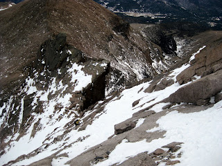
About 500 feet below the summit, a near-vertical step of about 150 feet bars the way. In years past, the National Park Service strung a cable up this section and it was the most popular route up the mountain. Since that time, the cable has been removed and all but 4 of the bolts cut that held it in place. Using the remaining bolts as well as a few additional pieces of protection, I led the technical pitch and Heather followed. It turned out to be much easier than reports had suggested. The mixed snow/ice/rock nature of the climb made it particularly interesting. I opted to climb it with an ice axe in my right hand and a gloved left hand, which ended up working very well.
Approaching the base of the climb
Above the technical pitch lies a few hundred vertical feet of leftward traversing to the summit. This section is class 4, meaning that it is somewhat steep and tricky but does not necessitate the use of a rope. However, the fact that an un-arrested fall would lead to a slide over the Diamond (an approximately 2000 foot vertical face) makes the use of a rope a serious consideration. Heather and I both decided that we felt comfortable enough on the terrain that we would climb the final bit unroped.

Heather above the technical pitch - or rather - above the Diamond
We reached the summit at about 12:45, 6 hours after leaving the tent.

Summit mug shot
We descended the same route, retracing our steps at the technical section in 2 rappels.

Heather rappelling down the technical pitch
We retrieved some water that we cached near the bottom of the climb and began a long slog back to our tent. We quickly packed up at the tent and continued back to the trailhead, arriving just as it got dark. Although we were hiking/climbing for about 11 hours, the nature of a steep north face route in the winter meant that we were in the sun for a total of about 15 minutes.
For anyone reading this looking for route beta, I offer the following. A 50-meter rope is enough to climb the technical section in a single pitch and descend in 2 rappels, both off of well-placed eye bolts. A 60-meter rope would not allow you to descend in a single rappel. With the bolts placed as they are, a rack of 6 cams (#1 and smaller) and 6-8 runners is sufficient for climbing this as a single pitch (I believe I placed 3 cams on the entire route and tied single runners to 3 of the eye bolts). At the time we climbed, there was intermittent ice up to about 2 inches thick, prohibiting screws from being of any use. Climb unroped above the technical pitch at your own peril.

The sole wildlife seen on the trip - a ptarmigan trying to blend in with the snow that really isn't there
On Saturday evening, the two of us backpacked up to treeline at about 11,000 feet on the Longs Peak trail (stupidly popular in the summertime, and well-traveled in the winter up to where we camped). We set up camp, melted snow for water, ate dinner, and went to bed early in preparation for a long day. The weather was moderately windy (20 mph sustained) all night but otherwise relatively warm (18 degrees) considering our location and the time of year. I experimented by bringing my ultralight summer bag rated to +45 degrees with the intention of wearing my insulated synthetic pants (thanks Al and Karen) and my synthetic parka inside of it. This worked really well and saved about 3 pounds in my pack. I think I could go down to about 10 degrees with this system. All this rambling and I haven't even gotten to the climb yet . . .
After two failed watch alarms, we got up at 6:15 and were on the trail by 6:45. We hiked up the sparsely snow-covered trail for about 3 miles along the standard Keyhole Route trail until we got to the Boulder Field. Up above treeline, the winds were sustained on the order of 25-30 mph for the duration of our climb. At the Boulder Field our path diverged from the standard route and we climbed a steepening face towards the edge of the Diamond.

The route route follows the green dots (you'll need to double click on the picture to see them). The red dots mark the beginning and end of the technical pitch.
About 500 feet below the summit, a near-vertical step of about 150 feet bars the way. In years past, the National Park Service strung a cable up this section and it was the most popular route up the mountain. Since that time, the cable has been removed and all but 4 of the bolts cut that held it in place. Using the remaining bolts as well as a few additional pieces of protection, I led the technical pitch and Heather followed. It turned out to be much easier than reports had suggested. The mixed snow/ice/rock nature of the climb made it particularly interesting. I opted to climb it with an ice axe in my right hand and a gloved left hand, which ended up working very well.

Approaching the base of the climb
Above the technical pitch lies a few hundred vertical feet of leftward traversing to the summit. This section is class 4, meaning that it is somewhat steep and tricky but does not necessitate the use of a rope. However, the fact that an un-arrested fall would lead to a slide over the Diamond (an approximately 2000 foot vertical face) makes the use of a rope a serious consideration. Heather and I both decided that we felt comfortable enough on the terrain that we would climb the final bit unroped.

Heather above the technical pitch - or rather - above the Diamond
We reached the summit at about 12:45, 6 hours after leaving the tent.

Summit mug shot
We descended the same route, retracing our steps at the technical section in 2 rappels.

Heather rappelling down the technical pitch
We retrieved some water that we cached near the bottom of the climb and began a long slog back to our tent. We quickly packed up at the tent and continued back to the trailhead, arriving just as it got dark. Although we were hiking/climbing for about 11 hours, the nature of a steep north face route in the winter meant that we were in the sun for a total of about 15 minutes.
For anyone reading this looking for route beta, I offer the following. A 50-meter rope is enough to climb the technical section in a single pitch and descend in 2 rappels, both off of well-placed eye bolts. A 60-meter rope would not allow you to descend in a single rappel. With the bolts placed as they are, a rack of 6 cams (#1 and smaller) and 6-8 runners is sufficient for climbing this as a single pitch (I believe I placed 3 cams on the entire route and tied single runners to 3 of the eye bolts). At the time we climbed, there was intermittent ice up to about 2 inches thick, prohibiting screws from being of any use. Climb unroped above the technical pitch at your own peril.

The sole wildlife seen on the trip - a ptarmigan trying to blend in with the snow that really isn't there
January 18, 2009
Schizophrenic Weather
Last weekend, Josh and I went backcountry skiing at Mayflower Gulch. The powder was deep and the skiing good, except it was a chilly 5 degrees out. It was so cold our skis stuck to the snow and our toes were frozen after the first run. Of course, Josh isn't bothered by any of this, but I am wuss when it comes to being cold. After hiking around awhile in hopes of warming up, we gave up and cut our trip short. But it was a fun couple hours in the snow.

This weekend, I stayed in Boulder to enjoy the spring-like weather. The 60+ degree temperatures made for some excellent bike rides and runs.

This weekend, I stayed in Boulder to enjoy the spring-like weather. The 60+ degree temperatures made for some excellent bike rides and runs.
January 14, 2009
Joseph of Nazareth
That's right, I'm a carpenter.
I recently completed my first major, self-directed wood working project. The goal of the project was to build a bed in the back of the 4-Runner capable of storing stuff underneath and sleeping on top. This is much like Keith's Tacoma, but with added complexities of a somewhat irregular shape to work with.
Design Criteria and Limitations:
1) The back portion needed to be self-sustaining (i.e., I need to be able to remove the front portion over the seats in order to use the seats while leaving the back intact).
2) The front portion needed to be split, allowing me to remove one side or both sides, thus allowing one or both of the rear seats to be utilized.
3) In any of the configurations, I needed to be able to sleep on it without suffering collapse.
4) My tools consisted of a cordless drill and a skill saw.
I began with a very nerdy three-dimensional design in AutoCAD. After approximating the interior shape and size of the back of the 4-Runner, I built my truck rack in virtual space.

This was intended to be more conceptual in nature, allowing me to build it in one attempt and minimize the amount of construction materials I needed to purchase.
In about 1.5 days of work, I believe I've accomplished all my objectives (I laid down on it without catastrophe). I've included a materials list on the off chance that anyone reads this and decides to pursue similar ideas of grandeur.
Materials:
4x8 sheet of 3/4 inch plywood
4x4 sheet of 3/4 inch plywood
1x1x48 inch board
Miscellaneous screws
6 cam-latches
And now, what you've all been waiting for, photos of the finished product! I think my Granddad would have been proud.


January 04, 2009
Backcountry Weekend
Yes, the snowpack here in Colorado is quite unstable, even by Colorado standards. Fortunately, these conditions don't prevent backcountry skiing, they simply play a larger role in dictating where it is safe to go.
On Saturday I ventured with Dane, Andy, and Dave to Mayflower Gulch near Hoosier Pass. Although it hadn't snowed for several days, it had remained cold since the previous storms, causing the old snow to ski like fresh powder. It did snow about 4 inches while we were skiing, but that was not nearly enough to account for the 12"+ that we were sinking into.

Andy having his way with the powder

The lone telemarker

Dane floating high on his split board
We ended up making laps in a patch of trees near treeline for about 5 hours - all of us with stupid grins that couldn't be wiped from our faces.
On Sunday, Andy and I were joined by Ben and Sean. After driving towards the town of Montezuma and discovering there wasn't enough snow, we backtracked to Mt. Quandary, where we had been 3 days ago. We knew the snow was good at and below treeline from our previous experience, so we went back in search of more powder.

We found what we were looking for.


Bringing in the New Year
I started 2009 off on a wonderful note with a ski descent of 14,265 foot Mt. Quandary. The weather report called for a high of 8 degrees with a wind chill of -27. Andy, Ryan, and I were prepared for the worst, but it turned out to not be nearly that bad.
After ascending the east ridge and reaching the summit around noon, Andy and I began our ski descent of the northeast bowls while we sent Ryan, on snowshoes, back down the ridge. The skiing up high was typical - windblown and highly variable. After descending 2500 vertical feet, we reached the treeline where the snow conditions changed from this highly variable awfulness to 8 inches of wonderful powder. The final 1000 feet of our ski descent was splendid. Ryan cruised down the ridge and we only beat him back to the car by about 5 minutes.

Andy with the summit in the background. It was too cold to take skiing photos.
Quandary is now the only 14er I've climbed 3 times, each time followed by a ski descent.
Subscribe to:
Posts (Atom)
