March 29, 2010

Hanukkah in March - Lake Tahoe

You've heard of Christmas in July.  Well, Ava and I just finished celebrating Hanukkah in March during a spring break road trip to the Lake Tahoe area.  We ended up skiing eight days in a row and ultimately drew parallels between 8 days of skiing and 8 days of Hanukkah, both of which are celebrations of the grandest kind.  I can't say thank you enough to Ava's parents for letting us use their place in Truckee!

On our first day we explored the Castle Peak area just off of the freeway near Donner Pass (about 10 minutes from Truckee).  We were quite pleased with what we found.

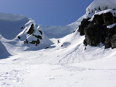
While wandering around on our first day, we stumbled upon this obvious couloir line on Castle Peak.  We started late and hit the snow at the perfect time of day!

Ava skiing down the couloir on Castle Peak

The skiing below the couloir was the best, so we made a second lap on the lower part before calling it a day. The next two days we stayed pretty close to the house.  We went skate skiing with Ava's mom, Nancy, one day and made laps in the backyard the other.  


Nancy having less than a lot of fun on skate skis

Ava and Nancy had never skate skied before, and I hadn't done it in about a year, so that was a lot of lung-busting fun.  While making laps in the backyard, we built a kicker (or "booter" if that's your preferred nomenclature) and proceeded to jump over a baby.


Me jumping over Blair

We were joined for the weekend by a slew of friends and relatives.  So, the following day, Ava went resort skiing with a bunch of her good friends from the Bay area while Dane and I went and explored some more in the Donner Pass area.  We found super windy conditions and a lot of short but well-featured lines.

The skiing wasn't great, so we experimented with ski-bouldering near the top of Donner Peak


We also dabbled in cornice breaking.  This failure didn't last long, but the rock that eventually broke it took both of us to lift, so we didn't get it on video.

We also skied

The next two days we got serious and drove an hour each way to the South Lake Tahoe area to ski some classic Tahoe peaks: Talac and Echo.  Talac provided us with amazing views of Lake Tahoe most of the way up.  It was a weekday, but we saw no less than 10 other people climbing and skiing the same route.  The pictures tell the story better than I can.

The upper bowl on Mt. Talac

Making a fashion statement

Skiing the upper bowl

Things were melting out fast, but that didn't stop us from being ridiculous.

Echo Peak was in the same area, but we couldn't see the lake for the first half of the ascent, so it lost aesthetic points.  However, the amazing terrain at the top of the peak more than made up for the short coming.  With a well setup snowpack, we decided it was reasonable to ski some steeper lines.

Skinning up through the big burn

Assessing the skiability of the snow arete and deciding which side to ski down.  I opted to eventually drop off the right (near) side while Ava and Dane dropped off the left side.

One of the more committing turns I've ever made

Ava getting ready to drop in

Ava below the threatening cornice

Dane styling the chute

After this incredible descent, which we eventually got cliffed out on, we made a second lap to ski the aspect that led to the car.  The skiing was great, but aside from the cornice at the top, it was much less dramatic than the other side.

Dane hucking on our second lap

Day 7 was a repeat of Day 1 up at Castle peak.  The differences were that this time we had Dane with us, the couloir was icy, and it was so much more melted out that it wasn't skiable in its entirety.  We planned to drive that evening to Mt. Shasta in attempt to put an amazing close to our spring break ski trip with a 7,300 vertical foot run from the summit.  The clear skies that were forecasted did not show themselves.  It snowed about 4 inches the night we arrived and continued snowing throughout the next day.  After sleeping in, we got up to ski some powder and managed to get within 6,000 vertical feet of our objective.  We made two laps from treeline in powder over icy crust, then drove to Eugene to stay the night with Jake.  I think this is long enough, so I'll elaborate no further.

March 11, 2010

The Most Popular Winter Climb in Washington? - Chair Peak, North Face

With only a couple days left in Seattle before road tripping for a few weeks, I was anxious to get one last adventure in.  A moderately questionable weather forecast left enough room for optimism that I decided Tuesday would be as good a day as any.  After calling Craig and convincing him to skip out on work, I received a call from Evan who was looking for a Tuesday climbing partner.  In a miraculous coincidence, Evan independently proposed climbing the same peak that Craig and I were already planning to climb.

Chair Peak from the Southeast (the right skyline is the Northeast Buttress)

We decided on the North Face of Chair Peak, conveniently located on top of Snowqualmie Pass.  We ambitiously hoped to also climb the Northeast Buttress on the same peak, but ended up not having enough time.

We skied the approach through 3 to 5 inches of light, cold powder over a sheet of ice (it hadn't snowed in the area for a long time until the previous day).  We skied nearly all the way to the saddle that marks the start of the Northeast Buttress route before switching to crampons.  We packed our skis up a little further and left them at the base of the northeast buttress before traversing to the base of the north face.

Evan Skinning Up, Craig and Source Lake in the Background

Craig (Luigi) with Chair Peak in the Background

With three climbers climbing on twin ropes, it's inefficient and a bit awkward to switch leaders in the middle of a climb.  Since Evan had climbed the same route 3 days earlier and Craig wasn't demanding to lead, I got the privilege of leading our team up the north face.

The route climbs straight up the ice and snow covered north face for about 200 meters.  It's never vertical, but quite sustained and up to about 70 degrees in places.  Three full (60 meter) pitches and a fourth shorter pitch put us a short scramble to the summit.

Craig and Evan in the Middle of the North Face

Me Leading the Second Pitch (thanks for the photo Craig)

The first pitch was more ice than snow with quite a few spots having ice good enough to place trustworthy screws.  I hammered in two solid pickets for the first anchor.  The second pitch and beyond was quite snowy, with a few trees here and there to sling as protection.  There was an option on the third pitch to stick to the right side of the gully and sling trees for protection, or head straight up the middle and hope for good ice.  I was pretty sure I saw a small patch of thick, solid ice about half way up in the center, so I took the more direct route.  I turned out being correct and was happy to place a bomber screw several meters before finishing the pitch at a nice tree anchor.  At the top of the final pitch, I had to wallow through deep, nearly vertical snow to gain the ridge top.  If it was any deeper, a tunnel would have been more appropriate.

Wallowing through snow near the top of the final pitch (thanks again Craig)


The summit views were amazing in all directions!

After spending several minutes on the top in much nicer than anticipated conditions, we began our descent.  This went very smoothly thanks to Evan knowing exactly where to go.  We climbed down the ridge to the east for about 100 meters before reaching a rappel station built of three old pitons.

The Old but Solid 3-Piton Anchor

Tying the twin ropes together, we rappelled 60 meters down steep snow before continuing to downclimb.  We were able descend to the elevation where we left our skis and traverse under the east face directly to our cache.

Craig Finishing the Traverse Under the East Face to our Skis

The ski down was variable, generally consisting of five inches of powder snow over one of the following: ice, icy crust, or avalanche debris.  Adding to this the flattest light conditions imaginable made the descent quite interesting.  At one point I went off a small jump, sunk deep into some icy crust upon landing, and proceeded to do a one-skied somersault.  Once we got back to source lake, the ski was flatter and on a well traveled trail resembling a bobsled course.

I think we left the parking lot at 8:00am and returned to the car at 5:30pm, for a respectable 9.5 hour day.  I didn't feel that we were particularly fast nor particularly slow.  The weather turned out to be fantastic and the fresh snow didn't negatively affect the conditions of the route, although getting to it was made slightly more difficult.  The fact that one can do an alpine climb of this quality in under 12 hours (Seattle to Seattle) from a major city warrants the popularity of this climb.  Climbing on a Tuesday was the perfect choice as we only saw one other party, and they were on a different route.

March 07, 2010

Going Native at Scottish Lakes


Ava and I just got back from a three-day weekend up at Scottish Lakes.  Jason (my cousin) and his wife, Katie invited us to tag along with them and a large group who had been doing this same trip for years.  Prior to this I knew almost nothing about Scottish Lakes, except that it was a backcountry ski hut destination.  Turns out it's a unique little operation, tucked away on the east side of the Cascades, just north of the Alpine Lakes Wilderness.

We were told to sign up for a shuttle time on Friday for a ride in (rides are offered about every 2 hours).  I'd been on many hut trips before but was never offered a ride in.  At the appointed time and place on Friday morning, a beat up Suburban and 4-Runner came down the private road, loaded us and our gear up, and drove up the gated road to the end of where it was plowed (about 4 miles).  At that point, we unloaded the vehicles and reloaded all our stuff onto snowmobiles and their accompanying trailers.  We continued another 4ish miles up to "High Camp" at Scottish Lakes.

High Camp is located in a heavily wooded valley at about 5,000 feet and consists of several living huts, a commons lodge, a hot tub, a sauna, and three outhouses.  The entire complex is staffed by a few individuals, who take care of everything from heating the wood-fired hot tub to a perfect 102 degrees to grooming cross-country trails.  A variety of good ski terrain is easily accessible within minutes of the camp.  Further away and higher up, the terrain becomes even more spectacular and variable.

On our first day we toured around in the vicinity of camp, discovering which aspects and elevations provided good skiing in the sunny, 40+ degree temperatures.  The conditions we encountered closely resembled spring conditions - classic corn snow on southern aspects.

Scotsman Shredding at Scottish Lakes

Ava's Huge Air

Based on what we skied and what we saw from our highest vantage points, we planned our next day's adventure.


Baldy

On our second day we aimed for Mt. Baldy, a peak we saw off in the distance the previous day.  It looked to have a large, open, southern aspect with lots of potential.  Six miles of skinning brought us to the base of Baldy.  Our first lap was everything we had hoped!

Early March Spring Corn on Baldy

On Top of Mt. Baldy

After our first lap on Baldy, we couldn't resist the more picturesque peak beyond baldy, so we hike up there for our second lap.

We were later told this is Mt. Thatcher, although we never saw it labeled on any maps.

The skiing wasn't quite as good on Thatcher, so we did another lap on Baldy for our third lap.  Running out of daylight, we skied over to the top of a couloir leading back towards High Camp for our fourth and final lap of a solid day out.

Halfway Through a Great Day Out!

As soon as we got back to camp, we went straight to the hot tub.  It was incredibly perfect and exactly what we needed.  Less than an hour later, the potluck dinner that all 32 of us had prepared for was underway.  I'm pretty sure I ate my weight in food, then had dessert.  Oh yeah, it wasn't easy, but we also managed to finish off the keg.

On the final day, we skinned up a short way before skiing 4+ miles down to the snowmobile/vehicle exchange.  If this trip sounds like any fun at all, I highly recommend finding your way to Scottish Lakes http://www.scottishlakes.com/Home.shtml.  Good luck getting a reservation, they start taking them exactly one year in advance.

March 04, 2010

Hawaii - Part 3

Our final few days were spent in the Kona area.  For the entire month of February, Dad was renting a condo in Waikoloa Village and had spent the two weeks before I got there finding the more remote sights and beaches in that vicinity.  I got to reap the benefits of his reconnaissance work before heading home.

On the first beach day, we hiked about 45 minutes to a beach that could only otherwise be reached via a burly 4-wheel drive road.  Consequently, there were only a few people there.  The next day we hiked to a couple pools that Dad had discovered a couple weeks before.  The first was filled with amazingly clear water and all the rocks in it were covered with gold algae - giving the pool a wicked cool gold-algae-in-the-middle-of-an-oasis look.  You know what I'm talking about.

Dad taking a golden bath - that almost sounds dirty

Later that day we got on the mega-tourist trail and found ourselves at Mauna Kea Beach.  This fit all of my stereotypes of Hawaii and had some excellent boogie boarding waves.  At one point I nearly got to use my WFR skills when a man was pulled from the water after sustaining a head/neck injury.

Mauna Kea Beach and Resort

Then there was the tsunami.  Since we were staying 6 miles from the coast and up over 2,000 feet in elevation, we were plenty safe.  However, we couldn't execute our plans as the coastal areas on all the islands were evacuated due to the perceived tsunami threat.  We spent most of the day sitting in the condo, watching the news as the tide rapidly went up and down as if it were possessed.  Several hours of this was enough to make us want to go out and play golf, so we did.

On our last day, Dad took me to see the Green Turtles.  These critters were amazing.  Amazingly lazy.

The name of these guys seemed to be a bit of a misnomer.  They really don't look that green.  If I got to name 'em, I'd call 'em Black and Tan Turtles.


The entire time we were hanging out at the bay watching the turtles, the tide was still fluctuating like it did the day before due to the tsunami.  Kinda creepy.  After bugging the crap out of the turtles, which were trying to sleep (that's why they go onto land) and probably a bit freaked out by the possessed tidal surges, we spent the last bit of time we had at Hapuna Beach State Park.  This was the largest beach on the island and a classic way to end the trip.  Too bad the waves were all screwed up by the tsunami effects to be any good for boogie boarding.

Hawaii - Part 2 (Hawaii Volcanoes National Park)

After thoroughly exploring the Kohala Mountains, we traveled across the island to visit the other hiking mecca on the Big Island, Hawaii Volcanoes National Park.  This new side of the island was dramatically different from where we had just come both from an ecological and geological perspective.

Views at the start of our hike to Halape

The lava flows were much more recent, including rocks that were less than 40 years old.  The ecological consequence of this was notably sparser vegetation; and as far as we were concerned, a severe lack of shade.


This plant seems to love growing out of lava rock - weirdo

We spent most of our time on a three-day hike to Halape, which was recommended to us by Megan (my cousin who studied Hawksbill Turtles there in the past).  We shuttled a car so we were able to hike in from the north, and out along the coast to the east.

 
The occasional vibrant flower seemed very out of place on our hike in

After losing about 2,600 feet of elevation in 8 miles, we arrived at a surprising oasis in the middle of an otherwise bland and inhospitable desert.


The Oasis known as Halape

Just as the map Megan hand drew for me at Christmas predicted, there was a brackish pool of water only a couple hundred feet from where we camped.  This pool was perfect for rinsing the much more salty ocean water off after swimming in the bay.


The Pond

One fun side experience was trying to break into a coconut.  I felt a bit like a primitive caveman, or possibly an ape, learning an elementary skill for the first time.  I eventually came up with an easy method for getting at the meat of the coconut while salvaging most of the milk (basically setting coconut on a rock and throwing another rock at it, then drinking the milk as it spilled out in a semi-controlled fashion).


After 1.5 coconuts, we couldn't stomach any more.

We spent most of the second day exploring our immediate surroundings.  Before long, we located the other spot shown on Megan's map: Halape Iki.  This was another oasis about a third of a mile west of where we were camped.  There was obviously much less people traffic here as it's not listed on any of the national park maps.


Halape Iki (we later confirmed our suspicions that "iki" means little)

When we returned from lounging at Halape Iki, we found that almost a dozen people had moved in where we had camped all by ourselves the previous evening.  To escape this unwelcome ruckus, we packed up camp and moved east along the coast to Apua Point, yet another oasis miraculously formed where the lava rock meets the sea.  This evening move turned our 11 mile hike out on the third day into about a 6.5 mile hike.  It was nice to break this up as the entire 11 miles was across barren lava rock, which grew monotonous after less than a mile.


Turns out I have a pension for taking pictures of waves as they crash into rocks


Our camp at Apua Point

We woke up early the next day to grind out the final 6.5 miles to make it back to our shuttled vehicle.  We stopped there briefly before continuing on past the car for 3/4 of a mile to the densest known zone of petroglyphs on the island at Pu'u Loa.


Classic shot of where the lava used to flow straight into the sea less than 40 years ago


A couple hundred year old chiseled turtle

After giving the petroglyphs their due admiration, we continued on the tourist path to the end of the road to take the picture of the sea arch that everyone else takes (for good reason, I suppose).


Holei Sea Arch

After that, we finished our tour of Hawaii Volcanoes National Park with a 4 mile hike around and through Kilauea Iki.  Unfortunately, there was no lava flowing within the park boundary.  We got word from a reliable source that we could go on a 6 mile round trip hike in the dark across private property to have a chance at seeing an active lava flow.  We opted not to.

March 03, 2010

Hawaii - Part I


Looking into Pololu Valley

I just returned from a two week trip to the Big Island of Hawaii. How does a jobless bum like myself afford such a trip? It's pretty easy, really. All you need is to have some time off. It also doesn't hurt to have a wealthy father spending time over there who wants some company - and a hiking partner.

We spent the first several days hiking and backpacking before heading to the beach to act like more traditional tourists. Part I of my posts will cover hiking in the Kohala Mountains in the northwest part of the island, and Part II will shed some light on our trip to Hawaii Volcanoes National Park on the south side of the island. I might even add a Part III, covering the few days we spent in the Kona area.

My first three days on the island were spent hiking in the Kohala Mountains, which stretch east to west on the northernmost tip of the island. Roads along the coast lead in from each side but are abruptly halted by rugged, picturesque canyons. On one trip, we hiked in from the west and crossed about three canyons (Pololu, Honokane Nui, and Honokane Iki) before turning around.

The coast line near Honokane Nui Valley

Part of the trail, quite steep with poor footing, was laced with ropes to aid both in ascent and descent (hand-over-hand style).

Dad, wondering if he can get back up the rope system if he goes down it

The views were great but caused me some confusion as I couldn't tell if I was in Jurrasic Park or Lost. There were no dinosaurs, but at the same time I knew where I was.

An additional short hike/bushwhack on the way home lead to this waterfall

Our second trip was a two-day backpacking trip that started and finished on the east side of the mountains at the famous Waipio Valley.


Looking across Waipio Valley to the start of the hike at the top of the obvious road cut

Waipio Valley

We hiked through a dozen smaller valleys to arrive and camp at Waimanu Valley, which is much like Waipio with the benefit of being more secluded - except for the ever-present helicopters above carrying an endless stream of tourists into the valley on a 30-minute, gas-wasting tour.

Our first views of Waimanu Valley

Looking up Waimanu Valley

The steep, rugged, and beautiful jungle terrain of Waimanu Valley

We encountered a few locals in Waimanu who were "living" there, hunting wild pigs, fishing, and gathering fruit for their subsistence. We asked how long they had been there, to which they replied, "two days." This was obviously a well practiced lie as camping in the valley is highly regulated (but with little to no enforcement, I'm sure they rarely encountered problems).

Future Ideas
I'm pretty sure a through hike between the two trailheads could be completed. We could find no literature on a complete traverse, but it would only be about a 25 mile hike (combining our two hikes, we did a total of about half the traverse). I'd recommend bringing a machete if you plan to attempt this.