Urubamba River Valley, near the start of the trail
The first day's hike was short and flat and served as a bit of a warm-up. Here we learned the routine of the porters carrying 70 pound packs and running in sandals. Some of them would stop at a predefined location and prepare a nice, hot lunch for us while the others continued to camp and had everything set up for us when we arrived. We also learned that the record time for completing the trek we were hoping to complete in 4 days is just over 3.5 hours. The porters were truly amazing and I would like to have brought one home with me.

Ruins near camp 1

Q'Entimarka Ruins near camp 1
We saw over 10 ruins in 4 days before arriving in Machu Picchu. Many of the ruins along the trail were quite extensive and really neat to see because there were no roads to them. Despite there not being any roads, small towns of only a couple families each were encountered sporadically throughout our trek.
The entire second day was spent hiking about 4000 vertical feet up a river valley, towards the highest point on the trail. We stopped to camp, as planned, about 1700 feet below the pass, leaving a fair bit of climbing for the next morning. I was able to convince the guides to let me do a side hike up to some ruins (Willkarakay) that do not lie on the main trail. This proved to be a fun experience as the ruins turned out to be in a fairly early state of the archaeological dig. I thought I was by myself when I came around a corner of a rock wall and found a donkey chillin' in one of the small rooms of the ruins.

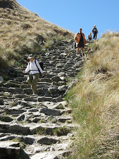
Typical trail on day 2
We camped at about 12,000 feet that night, causing some members of the group to have mild symptoms of altitude sickness. A couple of other members of our group were stricken with GI issues, which was everyone's nightmare heading into the trip. Apparently porters have carried sick and wounded gringos before, but nobody had to resort to that on our trip.

Huge valley we hiked most of the way up on day 2
The third day proved to be the most strenuous, with lots of steep up and steep down and no significant stretches of flat. This day involved crossing through Dead Woman's Pass, the highest point of the trip at nearly 13,800 feet.

Descending from Dead Woman's Pass
After descending almost 4000 feet we started up the next ridge, passing the intriguing ruins of Runkurakay about half way up to the next pass. Towards the top of this ridge, we had some good views of some of the more prominent glaciated peaks in the Cordillera Vilcabamba.

Runkurakay Ruins

Mt. Veronica
Descending from this second major pass of the day, we passed the rather extensive ruins of Sayaqmarka. I took a few minutes to run around inside while everyone else continued their forced march in attempt to get to camp before dark.

Sayaqmarka

Sayaqmarka
We traversed to another saddle on an exposed ridge where we found our camp that the porters had set up for us. After arriving to camp I peaked over the other side of the ridge and spotted the the ruins of Phuyupatamarka. As I had a bit more time until dark, I hiked around the ridge, up to the top of a small peak, and then descended to the ruins. I thoroughly enjoyed touring the ruins by myself and feeling like I was exploring. I then found the main trail that we would descend the next day and hiked back up to camp.

Phuyupatamarka
The next morning, I got up before breakfast in hopes that I would be able to see more of the surrounding mountains. Our guide told us that if it wasn't cloudy, like it was the previous evening, we would have some good views of the mountains. To my disappointment, there were still clouds in the direction of the supposed mountains. As the sun rose higher, the clouds began to burn off revealing the most spectacular mountain I have ever seen with my own eyes. Despite this peak's magnificence, it is only the 12th highest peak in Peru and the 38th highest in the Andes. I feel compelled to go climb some of them before all the glaciers melt, which the locals claim is happening at an alarming rate.

Nevado Salcantay (20,574 feet) seen when the clouds parted in the morning from camp 3

Salcantay
On the 4th and final day of the hike, we descended from our camp, passed the ruins of Yunkapata, through the ruins and town of Wiñaywayna (where we had our first beer in several days), through the Sun Gate where we caught our first glimpses of Machu Picchu, and down into the bustling crowd of tourists. It was here that I decided that I much preferred ruins that could not be driven to.

Yunkapata

Wiñaywayna Ruins

Machu Picchu from the Sun Gate
The first visual from the Sun Gate is the road of 25+ switchbacks leading up to Machu Picchu from the town of Aguas Calientes. The next thing I noticed was the tourist facilities and unsightly hotel immediately adjacent to the ruins. Thirdly, I noticed the ruins themselves through the smoke filled air. Apparently farmers in the valley were burning their fields this time of year, which is against the law, but the laws are not enforced.

Machu Picchu (Wayna Picchu peak in the background)
We pretty much went straight to a hotel in Aguas Calientes as it was late in the afternoon when we arrived at Machu Picchu. The next day we returned for a few hours dedicated to touring the ruins. I got on the first set of busses leaving Aguas Calientes at 5:30 am with about 300 other people in order to get a pass for hiking up Wayna Picchu, the steep peak in nearly all Machu Picchu pictures with some small ruins at the top. It was raining on the bus and foggy up at the ruins, but after getting my pass (which are limited and typically sell out by 7:00), I immediately began hiking up the peak. On the way up, I could never see much further than about 30 feet due to the dense fog. Near the top there were some more ruins and the fog began to relent.

Steep and foggy hike up Wayna Picchu

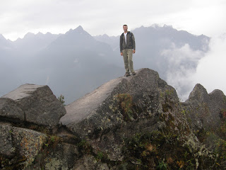
At the top of Wayna Picchu
At the top I found that 3 others who had been near the front of the ticket line had beaten me to the top. Even with the summit free of clouds, I still didn't think I'd get to see the main ruins as the sky was completely white below us. Gradually, I could start to make out some dark shapes in the white sea of clouds, then a small opening, then a very brief clearing that lasted only a few minutes when I took the picture below.

Machu Picchu from the summit as the clouds briefly parted

Ruins near the top of Wayna Picchu
After the hike, I met back up with Dad and the rest of our group for the latter half of the tour they were on. We didn't see the clouds part again for the rest of the day.
The Incas sure did live in some incredible places and built some amazing structures. While Machu Picchu was the most extensive collection of ruins we saw on the trip, it was not necessarily my favorite due to the crowds, nearby modern development, and road access.

Machu Picchu
Later that day we took the train from Aguas Calientes back to Cusco. I would normally leave such trivial aspects of the trip out, except for this one interesting subject that I will not be able to adequately explain in words. About halfway through the 3 to 4 hour train ride, music began to play in our train car. Just after this, the two attendants (one male and one female) began taking turns strutting up and down the aisle in a full on fashion show, changing clothes after each lap. These people had obviously watched fashion shows before and had the unnatural struts and poses down as well as anyone. To top it all off, the first song played as this started was Abba's "Dancing Queen". This went on for nearly 2 hours, enough time for the Japanese contingency in our car to take about 2000 pictures each.
No comments:
Post a Comment