December 11, 2012

Archery Success!

While I still stand behind my argument that hunting success can be defined as going hunting, having a great time, and coming home with exciting stories, this time success took the form of my arrow resulting in freezer fodder.  Yes, after two years of semi-dedicated hunting, I killed my first big-game animal!


For the late archery season, I was inspired by Kris's success hunting blacktail on Whidbey Island on Ann and Ron's property.  Luckily, Ann and Ron were still excited about culling the deer population around their home, so I had no problems obtaining an invite.  I ended up traveling out there on the last day of November with Pat (Ann's brother). Evan, who had never really been exposed to hunting and wanted to see what it was all about, joined us the following morning.

On December 1st, I was up in the second story of their barn shortly after first light.  My plan was to use the elevated vantage point to locate deer, and then figure out how to hunt said deer based on their exact location.  If things went perfectly, the deer would walk within shooting distance of one of the windows and I wouldn't even have to stalk it.  The barn was my glorified tree stand.

After a few hours of seeing no deer, Evan showed up.  We proceeded to spend the rest of the morning playing cribbage in the barn, waiting for a deer to walk by.  The deer continued to elude us for the rest of the morning, at which point we decided to try Ron's idea to hunt some of the property he owned about a mile away.  With me stationed along a fence line, Ron, Pat, Even, and 'T' (Ron's grandson) tried to jump deer and push them toward me.  In doing this, Ron and 'T' jumped two deer, but I never saw them.

I made sure to be back in the barn for the couple hours before dark as I thought this the most likely time for deer to be up and about in the yard.  Several hands of cribbage later, Pat came out to the barn to join Evan and me.  Pat would periodically check out one window while I played cribbage with Evan from a location where I could see out the other.  About a half hour before dark, Pat walked over to the window he was diligently checking and calmly announced there was a deer outside.  In a much calmer manner than I felt internally, I replied, "Really?  That's great.  We've been looking for one of those."  I grabbed my bow and hurried over to the window.

Sure enough, there was a deer standing in the yard, which I ranged at 24 yards.  It was quartered toward me, effectively blocking any shot at it's vitals.  As I was meat hunting and this was a reasonably good-sized deer, I decided to shoot as soon it presented a shot.  For what seemed like an eternity but Evan confirmed was actually about 6 minutes, the deer continued to feed while quartered to me, it's front shoulder safely guarding it's vitals.  During that time, I was able to study the deer and convince myself I was calmer than I was.  I noticed what appeared to be two light colored markings on it's fur right above it's eyes.

After about 6 minutes, the deer finally took a step and rotated into more of a broadside position.  With what seemed like pure instinct, I drew my bow, sighted my 20-yard pin about an inch higher than I wanted my arrow to land, and slowly squeezed the trigger on my release.  The next thing I knew, the deer had dropped right where it stood, kicking around on the ground.  I instinctively knocked another arrow and shot a second time.  With two arrows though both lungs, the deer expired quickly.


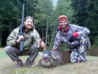
After walking up to the deer, I noticed that the two light patches I had mistaken for off-colored fur were tiny spike antlers, about 1.5 and 3 inches long.  Turns out I shot a young buck!  In the waning light, Evan and Pat took pictures while I posed with my first archery kill.  After about 35 days of bow hunting over the last two years, I finally turned an arrow into something more calorically valuable.  Thanks to Evan, Pat, Ann, Ron, and 'T' for helping make this happen!  Additional thanks to Evan and Pat for helping me process the deer, and thanks to Ava for supporting me in my hunting endeavors.

While hunting in a rural area with a severe deer overpopulation did not present the same challenge as the more wilderness-oriented elk hunts I've been on, it served as a great stepping stone in building my confidence in shooting at wild game, which is vastly different than a target.  I now have a renewed excitement and confidence leading into next year's September hunting season, but for now, it's ski season!

December 09, 2012

Deep Deep Pow Pow

My first day of ski season was downright epic.  With 39 inches of light, fresh snow, face shots were plentiful and breaking trail was burly.  Ava, Craig, Melissa, and I made our way up to Skyline Ridge (across from Steven's Pass Ski Area) on December 8th.  Even on 25 to 30 degree slopes, building speed was a challenge.  The entire day seemed to be in slow motion.  Images of Ava skiing down with snow billowing over her head were classic and would have been worthy of a magazine cover if we'd managed to capture it properly.  While breathing was often difficult for me while skiing down with blower powder seeking the depths of my lungs, Ava would literally have benefited from a snorkel.  Thanks to Craig for capturing a few shots and videos of the day's antics.

Josh

Josh's Head

Ava

Ava


November 27, 2012

13.1

After a 5-year hiatus from my amateur running career, I decided I don't hate running anymore.  With group motivation provided by Molly, Ava, and myself, we all trained for and ran the Grand Ridge Trail Half-Marathon near Issaquah, WA.  The trail was primarily and out-and-back (or in-and-out as Molly liked to call it) with a slight deviation in the middle.

Looking at past race results, I thought I'd have a chance to do really well based on winning paces of around 8 minutes per mile.  It didn't take long for me to realize that this was a blistering pace considering the 2,000 ft of elevation gain and loss over the 13.1 mile course.

The run itself was relatively uneventful as controlled falling on alternate legs brought us up and down hills on terrain that never seemed to be flat.  We all ran together until the first downhill, at which point I let gravity take over and started passing people.

I steadily passed people as the race progressed, and almost nobody passed me.  I was super happy with this as it meant that I didn't go out too hard and peter out toward the end.  Rather, I paced myself well and picked up the pace toward the end.

I was hoping to complete the race in under 2.5 hours.  When all was said and done, I finished in 2:18:08 with an average pace of 10:32/mile.  While far from making the podium, this was good enough for 17th place out of 161 finishers.  Molly came in 37th and Ava finished in 49th, all within about 18 minutes of one another.

Professional photos taken during the run:
Molly and Josh
Molly
Ava

The run served as great motivation to get in shape, which was my primary reason for paying to do something that I do all the time for free.  Seeing as I didn't injure myself during the training or the race, I think I might do something like this periodically as my fitness carrot.  But for right now, it's time to wrap up the hunting season and focus on skiing some epic northwest powder!

October 23, 2012

Meat in the Freezer

This year Kris drew a multi-season deer tag for Washington.  This means that he was able to hunt the archery season, muzzle loader season, and rifle season with the appropriate weapon.  Without this tag, you have to choose one.  After drawing the tag, Kris went out and bought a rifle so he would be prepared in the very likely event that he didn't shoot a deer with an arrow during bow season.

A short while and a little research later, Kris realized he had an opportunity to hunt blacktail deer on his aunt-in-law's (Ann's) property on Whidbey Island.  That was the good news.  The bad news was that hunting with rifles is not permitted on the island, so Kris had to purchase a shotgun.  Shotguns are allowed as the bullets (slugs) they shoot travel much shorter distances than those from rifles.  With the proper gun acquired, Kris was ready to take advantage of this opportunity.

Regulations on the island allowed Kris to shoot "any deer".  As he had never killed a big game animal before, he had no intentions of being picky.  The first deer to get within about 100 yards of him was going to get a shot fired in its general direction, possibly getting hit depending on how well Kris sighted in his shotgun and was able to control his excitement.

About 15 minutes before daylight last Saturday, Kris and I made our way to the top (second) story of Ann's barn.  We removed the screens from a couple windows and situated ourselves so that we could each look out windows facing in opposite directions.  About 10 minutes after it started to get light, I saw a rabbit on my side, so I told Kris to come over and practice sighting his rifle on fur.  He did this, and a short while later the rabbit bounded out of view.  When Kris returned to his post at the window opposite the bunny, he immediately noticed a deer standing in the yard below him, oblivious to our presence.

He became so excited that speech became difficult and his coherency diminished.  I heard him utter, "There's a deer over here," so I walked over to see what was causing his altered mental state.  When I looked out the window in the early morning light, I remember thinking, "That's a pretty big doe for an island blacktail . . . wait . . . it has antlers . . . it's a buck!"  At this point I became about half as excited as Kris, which is really freaking excited.  However, I was able to overcome this and talk Kris through the next few steps, pretending to be calm the entire time.  It seemed we had plenty of time, so I told Kris to range the deer.  He did this and ranged him at about 75 yards.  I knew his first two reticle points in his scope were for 50 and 100 yards, so I calmly advised him to get a good rest and hold the area between those two dots right behind the buck's front shoulder.  Of course, Kris knew all this but his excitement was getting the better of him at this point and I think a calm, methodical voice helped him out.

Meanwhile, the buck was standing broadside in the middle of the yard like he was posing for a photo shoot for several minutes.  He wasn't feeding, wasn't bedding down, just standing there waiting to get shot.  At one point, Kris knocked something over in the barn, and the buck looked up and seemed nervous for a few seconds before going back to standing broadside.  After I moved a chair out of the way, Kris got a good rest on the window sill and mentioned how nervous and shaky he was. I calmly advised he take a few deep breaths, make sure his safety was off, take his time as the buck wasn't going anywhere any time soon,  get a steady hold, and ease the trigger.

Ten seconds later, "BOOM!"  Simultaneously, the deer reared up on it's back legs and bounded into a ravine and out of site.  I could tell by the way the buck jumped that he had been hit solidly, but I didn't know exactly where.  Two seconds after shooting, Kris burst into exuberance: shouting, hugging me, shouting some more.  At this point, we both felt like all the hunting days we put in over the past two years was finally going to result in some treats for the freezer.  While it only took about 25 minutes of "hunting" to put a bullet in this buck, we'd collectively hunted hard for about 40 days over the past two years with nothing tangible to show for it.

After waiting for a couple minutes, we decided to go down and see where the buck had gone, hoping that he hadn't run onto someone else's property to die.  As soon as we got to the edge of the ravine, Kris spotted the buck not 20 yards from where it stood when he shot it.  Now it was really starting to register with me that while Kris would have been more than happy with a doe, he had just killed a big-bodied forked horn!  And a pretty nice one by island standards.


We took several pictures before dragging the buck to a convenient processing location at the edge of the yard.  Since it was only about 7:45 am, we took our time, harvesting as much meat off of the deer as possible.  We then had to pack the meat about 130 yards to the driveway.  Later that evening, Ava and Mel joined us on the island and we all had a terrific, local, fresh, organic, free-range meal.


After the excitement wore off, I realized that this was the first time that I had been the most experienced hunter in a group when an animal was harvested.  When other, more experienced people are involved, it's easier to be successful but harder to feel much ownership in that success.  In this instance, Kris and I more or less had to work together to figure things out, making his/our success immensely more rewarding.

I occasionally lose sight of the fact that Kris shot this buck, mistakenly thinking I had a bigger role in it than I did.  I am responsible for getting Kris into hunting less than two years ago, and I like to think that my calm coaching in the heat of the moment was also very helpful, but Kris did the rest himself.  I am very happy I was able to accompany him on this successful outing and I hope to accomplish something very similar with my bow in December.

August 19, 2012

Prusik Peak - West Ridge (P in a D)

Fed up with the prospects of trying to obtain a permit to camp in the Enchantments area of the Alpine Lakes Wilderness, we decided to climb the West Ridge of Prusik Peak in a day (or P in a D).  In this instance, "we" refers to Kris, Evan, Ava, and me.  Prusik is typically climbed in two days as the approach is about 10 miles and gains close to 5,000 ft in elevation.

After spending Friday night at the Stuart Lake trailhead, we left at 4am.  We made it to Colchuck Lake in two hours.  Two hours after that, we arrived at the top of Aasgard Pass.  Aasgard gets a bad rap because the trail gains 2,200 feet of elevation in 0.8 miles, but it really didn't seem that bad.  The trail is easy to follow and in good condition considering the terrain it ascends.

Beautiful views in the Alpine Lakes Wilderness

Seems I've been seeing a lot of these guys lately
Once over Aasgard Pass, you enter the upper Enchantment Basin, which is much less steep than the other side of the pass.  We descended about 700 feet on the other side of the pass before climbing back up to Prusik Pass and the start of the technical climbing.

Evan, Kris, and Ava about 9.5 miles into the approach.  Prusik Peak in the distance.
Six hours after we started (10am), we were roped up and climbing.  Kris and Evan climbed as a team, and Ava and I climbed as a team.  Since the terrain was relatively easy as far as 5th class climbing goes, we "simul" climbed.  And by "simul", I mean that we pitched out the climbing but basically climbed side-by-side (Kris and I lead close together and Evan and Ava followed close together).

Starting out on the final pitch
After 5 pitches of climbing, we all arrived at the summit in fantastic spirits.  The weather was beautiful and not as overwhelmingly hot as we thought it was going to be.  I won't do a pitch-by-pitch, but suffice it to say that the climbing involved a bit of crack climbing, some face climbing, a little slab climbing, a chimney, and a super positive and fun lieback on a flake - all in only 5 pitches on fantastic rock in a picturesque, alpine setting.  We also didn't see anyone else on route, which we all found surprising given the popularity of the route.

High-spirited summit shot
After 4 single-rope rappels down the north side, we traversed back to where we started climbing on the west ridge and started retracing our steps.

Prusik Peak from the southwest (the West Ridge route follows the left skyline, often just off the crest on the opposite side)
We stopped for a short time at one of the many lakes in order to refill our water vessels and splash around.   Other than this, it was pretty much all business getting back to the car.  Fifteen hours and 20 miles after we started, we arrived back at the Stuart Lake Trailhead and the car.  We proceeded to drive into Leavenworth for a much-earned pizza feed before Mario Andretti . . . no, Bowser. . . wait, I mean Kris, drove us home to Seattle by 11:30 pm.

Although a long day, it was so enjoyable and beautiful it seemed to fly by.  There's really not much that can compare with an outing like this with great weather and even better company.

August 12, 2012

Joj-cel the Scrambler with Shoes On

If you don't get the title reference, please watch both of these:

Marcel the Shell with Shoes On (One) http://vimeo.com/33097773
Marcel the Shell with Shoes On (Two) http://vimeo.com/32189414

Now that we're all on the same page, I should inform you that the title is barely relevant.  During a recent NOLS rock camp in Leavenworth, I blew out my beloved pair of approach shoes (hiking shoes with sticky climbing shoe rubber, to the lay person).  I took Friday off since I have to work this weekend, so I planned a last-minute scramble, then realized I didn't have any approach shoes.  So I did what anyone else would do and left work at lunch time on Thursday to buy a new pair at REI.  I ended up buying the only pair they had in my size, which turned out to be a La Sportiva Boulder X.


The Plan: Climb a whole bunch of peaks in the Tatoosh Range, immediately south of and very close to Mt. Rainier.

Motivation: Perfect weather forecast, fun scrambling on "high quality choss" (if that's a thing), and spectacular views.

Details:

I started up the Pinnacle Peak trail at about 0730 and was quickly at the saddle between Plummer Peak and Pinnacle Peak.  I hung my pack in a tree and jogged up to the summit of Plummer and back.  Plummer was the least technical, so I felt good leaving my pack which contained, a rope, harness, and minimal amount of gear in case I needed to build an anchor.

Marcel the marmot with no shoes on
Back at the saddle, I didn't have far to go before the first of many "business ends" of the traverse began.  I went up the south face of Pinnacle on some loose-ish but never very steep rock.  From the top, I decided to explore the possibility of descending the east ridge.  I'd heard the east ridge was sporting to ascend, so I reasoned it would be at least as sporting to descend.  I was prepared to back off and descend the way I came up, but it never got very tricky, albeit exposed in places.

The views were okay
The distance from the base of Pinnacle's east ridge to The Castle's south face was negligible, so I was quickly scrambling back up more high quality choss.  My recollection of The Castle is that there were some steeper low 5th class moves, but the exposure was much less than on Pinnacle, making for some very enjoyable scrambling.

Pinnacle Peak (from The Castle)
I descended Castle using a slight variation from my ascent route.  My overall impression is that there are a multitude of possible lines on the south side of The Castle, all of which are equally difficult on similar and decent rock.

The Castle was separated from Unicorn Peak by a 2.5 mile-long ridge with two significant and unnamed peaks between them.  The first was an easy scramble up to point 6,254 feet, followed by a gradual descent and traverse across a beautiful, flat ridge covered in wild flowers.  Then I was going up again.

Throughout the day, the views failed to deteriorate

From a distance, the northwest aspect of Steepchoss Peak (this is what I'm calling the peak immediately west of Unicorn Peak, separated only by a single, prominent saddle) appeared rather intimidating.  I told myself that it only looked that way because I was looking straight at it, and that in reality is probably wasn't as steep as it looked from my vantage point.  So, with rope and harness at the ready for a possible bail, I started up old Steepchoss.  The first half of the ascent went great, and I was totally right about it not being as steep as it looked.  A little over half way up, there was a bit of a headwall of near vertical rock for about 30 feet.  I spent a bit of time wandering around looking for a reasonable way up.  I eventually found an easy but exposed weakness in the rock which led to easier ground and eventually the summit.


Handsome goat at the base of the Unicorn horn
The east side of Steepchoss was less steep but more chossy, so I decided to keep the name.  I carefully descended to the saddle from where Ava and I had skied down less than two months earlier.  From here, I knew the route to Unicorn, although it was a bit different in places with substantially less snow.

Optical illusion: the namesake horn on Unicorn Peak is not actually the same size as Mt. Rainier
When I got in view of the horn on Unicorn Peak, I heard what I thought was the first person I'd encountered all day.  I was wrong.  It was a goat.  Like a good, respectable goat, he kept his distance and posed for some photos.

Joji: Hey goat, why don't you be a little more photogenic.
Goat: Sure!  I'll just go skyline myself and turn broadside.
After the goat skittered across a snow patch and out of view, I continued to the horn and ascended the 4th class east ridge.  It felt a little 5th-classy, but that could have been due to the exposure to the north.  While the climbing is less interesting than the 5.6 south side of the horn, the view and position are superior.  Since this was the last summit of the day, it felt like summit of the trip (it also happens to be this highest point in the Tatoosh), so I took some obligatory summit photos.

On top of Unicorn Peak with the views still not sucking (photo courtesy of Tripod)
The adventure was not over.  I didn't feel good about downclimbing the way I came up, so I pulled out the rope for the first and only time of the trip and rappelled the south face.  From the base of the horn, scrambling down to the saddle (center of the photo below) was easy.  At the saddle I encountered my first snow of the trip.  It was sufficiently soft at the top to heel plunge, but as the angle steepened the north face phenomenon took over and the snow firmed up.  It firmed up to the point that I wish I had two things: crampons and boots that were compatible with them.  I was, however, minimally prepared for such conditions with an axe.

. . . and that's why they call it "Unicorn", like an air-breathing narwhal with hooves.  Steepchoss Peak is on the right.
The descent was slow for a couple hundred feet as I kicked steps and braced with the axe, eventually choosing hideous scree over more painstaking step kicking.  I made up some of the lost time with some top notch boot skiing a little while later.

I made it down to snow lake and jumped in just as soon as I could take my shoes off, temporarily making a lie of this post title.  The yelling idiots I encountered at Snow Lake successfully reminded me that I was in a National Park.  I owe them one for breaking me free from my delusions of wilderness adventure, possible preventing catastrophe as trip over a paved road and get hit by a car a mile down the trail.  Once I made it to the road it was an easy 2 mile walk back to my car.

I completed the trip in 7 hours and had a great time moving through the mountains, alone but for the occasional critter.  I love my new shoes and thought they performed very well.  They seem to have all the advantages of my late pair of approach shoes with improvements in the areas of edging on rock and step kicking in snow.  This also happened to be Ava's and my negative first wedding anniversary, so it was nice to be alone for the day with my thoughts (seeing as she was off teaching a backpacking trip for the Y, this seemed like the next best option).


July 12, 2012

Fourth Time's a Charm

I had previously tried to climb Mt. Rainier on three occasions: twice via Liberty Ridge on the north side of the mountain and once via the Emmons Glacier on the east side.  For the last several weeks I've had an itch to try and ski off of the summit, with the primary goal of actually making it there.  With shitty weather up until the 4th of July, last weekend was the first weekend suitable for such an attempt.

I sent out an email and quickly rounded up Brian and Rodrigo as climbing partners.  Ava decided to join us the evening before we left, making us a group of four.  I had decided to attempt the Emmons Glacier route because I was most familiar with it and it's also the least technical route on the mountain, making it more suitable for a less harrowing ski descent.


Who doesn't love sunrises at 12,500 ft?

The route ascends 10,000 vertical feet in about 8.5 miles.  Our plan was to head up to Camp Schurman (picking off about half of the elevation gain) on Saturday and summit and return to the car on Sunday.  Two solid days in a row, but manageable provided the altitude didn't twist our sea-level softened lungs up too bad.


We arrived at the Sunrise Ranger Station about 10 minutes before they opened (second group in line), and were the last group to receive a permit to camp at Camp Schurman.  Apparently the rest of Seattle was waiting for the first nice weekend of the year as well.


We may have put the skis on a little too early


With full packs on plus skis on our backs, we headed for Schurman.  About four miles later, at Glacier Basin, we were able to put our skis on and skin the rest of the way.  We intentionally maintained a leisurely pace the entire day to maintain energy for the following day.  Even so, we arrived at camp by 3:00, leaving plenty of time to melt snow, eat, and hydrate before going to bed.  Ava had developed a headache on the way up which worsened after we got to camp.  Rest, food, water, and Diamox eventually reversed this, but we all agreed it would be best if she didn't go up further.


Camp Schurman

That evening I chatted with the rangers staffing Camp Schurman about this ski conditions, what to expect, and when would be the best time to descend.  They recommended descending quite late (3pm) to allow as much of the ice up high to soften as possible.  I was also informed of the one crux of the route, a dicey little snow bridge that was about to melt out in awkward terrain with crevasses all around.  This would turn out to be the one and only place a skier would need to rope up on the descent.  As Brian and Rodrigo would not be bringing skis with them, I would be skiing alone and have no one to rope up with when I arrived at the crux unless I waited for them.  This, combined with the recommended late descent, made me decide to stash my skis just below the suspect snow bridge at about 11,700 ft.  I felt more relieved at going to bed with a concrete plan than disappointed about giving up on my hopes of a summit ski descent.


Brian, Rodrigo, and I got up at 1am and were moving up the mountain about 40 minutes later.  By the time we started, there was a pretty steady stream of headlamps from camp (9,500 ft) up to about 12,000 ft.  With Brian in the lead, we moved steadily up the lower part of the mountain, passing several slower groups as we went.  When we stashed my skis below the snow bridge at about 11,700 ft, we encountered a bottleneck that had been developing for some time.  We killed about 45 minutes here, which was frustrating but provided a situation where all we could do was eat and drink.  This extra eating and drinking came in handy as the day progressed.


While one would definitely want to be roped up for it, the bridge turned out to not be as bad as advertised.  The rest of the way to the top was sustained in steepness and littered with other climbers, all of whom seemed to be moving painfully slowly.  In several more places we were forced to wait as groups stopped in inconvenient spots for long periods of time - more eating and drinking.


Nearly the whole day the wind had been quite gusty, with frequent 25 to 30 mph gusts.  As we neared the top, we got reports from descending parties that the wind on the summit was horrendous.  After reaching the top of several false summits, we gained what seemed to be another one, only this time the wind was no longer gusting, it had turned into a steady 35 mph headwind.  A short walk through this wind on the rocky ridge of the crater rim brought us to the true summit at 14,410 ft.  We took a few quick pictures before retreating back to the leeward side of the mountain.


Brian, Joji, and Rodrigo at 14,410 ft in Washington
(I'm not mad, my face is just numb from walking into the wind so I couldn't control it)


Descending as a rope team always seems to take longer than it needs to, and this day was no exception.  We eventually made it back to the crux snow bridge and attempted to find an alternate passage.  An alternate passage we found, but it was arguably just as sketchy while being more technical - oh well.  After the bridge, Brian and Rodrigo dropped me off at my skis and continued descending.  I radioed Ava back at camp to inform her that I was going to start skiing, and she proceeded to take some video with the camera.  Unfortunately, I'm not visible in most of these because, although in a direct line of sight, I was too far away.  I descended the 2,200 vertical feet in about 5 minutes and was happy to rest in camp for a bit before continuing our descent.


Rodrigo and Brian showed up in camp about 25 minutes later looking like hell.  Apparently the sticky snow I had skied on the last 1,000 ft had been a postholing nightmare for the two of them, sapping the last of their energy.  Thankfully, Ava was an amazing camp host and already had lots of snow melted for water and was in the process of cooking up some pasta.  We rested, ate, and hydrated in camp for about two hours before continuing our descent.


Skiing down the Inter Glacier


The ski down from camp started out treacherously sticky, but counter-intuitively got better as we went down.  The Inter Glacier turns out to be a super fun, sustained pitch to ski even with a full pack.  Once back at Glacier Basin, we put the skis back on the packs, Ava and I switched to running shoes, and we hiked the last few miles back to the car.


Ridiculous


While nothing on the route was difficult, it did prove to be a beast of a hike with plenty of elevation gain.  I'm psyched to have made it to the top and  super happy with how well my body handled the altitude and the back-to-back long days.  Now it's time for some warm, sunny rock climbing.

July 02, 2012

Enchantment Traverse: Medium and Light Style

With mediocre weekend weather in store once again, Ava and I decided it would be a good weekend for a long hike.  We devised a plan to hike through the Enchantments in the Alpine Lakes Wilderness in a day, intent on going fast and light.  This is a more or less horseshoe shaped traverse, starting and finishing at two different trailheads about 8 miles apart.  The idea was to run/hike from the Snow Lake trailhead to the Colchuck Lake trailhead via the glorious Enchantment Traverse,and hitchhike back to the Snow Lake trailhead.  Reliable reports of the distance and elevation gain for the route were hard to come by.  My current best estimate is about 18-19 miles with 6,700 feet of elevation gain.

About 2 minutes into our run, we were forced to admit that hiking was a more appropriate mode of travel given the incline of the trail, our fitness level, and the long day ahead.  So, 2 minutes into the day we set a standard of overestimating our abilities and underestimating our adventure, which would last for the next 9 hours.

For the first several hours, we walked, ate, and drank in a repeating fashion as we ascended deeper and higher into the Alpine Lakes Wilderness.  As we neared what we thought was the halfway point, we were continuously assessing our decision to commit to the traverse or turn around and retrace our steps.  The main unknown in our decision centered around the fact that the highest point on the route, Asgard Pass at about 7,800 feet, would meet us at about mile 12.  Most of the trail was snow free, but we were unsure of how much snow the pass would hold and how steep of snow slopes we would have to travel on in our running shoes without ice axes.

With no shortage of people scattered about this popular wilderness destination, we stopped to ask people with a trustworthy appearance about the conditions on Asgard Pass.  Descriptions ranged from, "It's really steep and we heard you need spikes," to "It's not bad.  You should just go for it, but leave now because it's getting late and it will take you a while".

I failed to mention that we didn't leave the trailhead until 12:45, thinking we could optimistically complete the run/hike in 5 hours, maybe a couple more in a less optimistic, more realistic world.  I think it was about 6:45 when we were still 2 miles from the pass and asking backpackers what they knew.

One favorable report was all we needed.  Thankfully, that report came from a group of backpackers who had just come over Asgard Pass and left a nice trail of boot steps in the snow for us to follow.  Without their tracks in the snow, I'm sure we would have turned around as the navigation is less than straightforward up there and we were sans map and compass.

So, we kept walking, drinking, and eating, but now with a slightly higher degree of urgency.  We arrived at the top of the pass to be pleasantly surprised by finding the other side almost completely free of snow.  However, the reports of steepness were not exaggerated.  We descended about 2000 ft in the next mile, at which point we reached Colchuck Lake and the trail became much flatter and well-maintained.  We actually did run some of the last few miles to the trailhead, partly motivated by the waning light.

We arrived at the trailhead at 9:45, taking exactly 9 hours to complete the traverse.  Since it took us much longer than anticipated, our hitchhiking plan more or less turned to shit.  I'm sure many vehicles were travelling the gravel side road to and from the trailhead about 2 hours earlier, but that didn't do us much good.  So, we kept walking.

About 3 or 4 miles later, the first two vehicles travelling our direction approached.  The first drove by without slowing, but the second stopped and happily gave two smelly hitchhikers a much appreciated ride.

I think we traveled 22 miles in total, running for about 1.5 of those.  Despite our underestimation of our objective, we had a great day out and felt surprisingly good at the end.  Given the rugged nature of large sections of the trail, I don't feel too bad about our final time, even though it was much slower than expected.  While I can't call our speed fast, it also wasn't slow.  And since we didn't take very much with us, thereby travelling very light, I'm quite comfortable referring to our style as "medium and light".  I hope we inspire others to partake in this new offshoot style of backcountry travel.  It maintains many of the benefits of fast and light while proving to be much more pleasant and enjoyable.

June 18, 2012

What do you get when a narwhal mates with a horse?

With a suspect weather forecast, Ava and I opted to attempt to execute our plans of climbing Unicorn (yes, that's the answer to the title question) Peak in the Tatoosh Range, due south of Mt. Rainier.  We almost didn't bring our skis but ended up being really glad that we did as there was snow all the way to the parking area.

Most of the way up, the mountain was obscured by clouds.  The few moments of clarity we had barely lasted long enough to get a camera out, but I managed to be quick enough on the draw once or twice.

Unicorn Peak during a blessing of visibility
Shortly after that picture was taken the clouds came back in, engulfing not only the mountain this time, but us as well.  We managed to skin most of the way to the top, until the increasing slope and decreasing visibility (down to about 20 feet at times) inspired us to put our skis on our packs and our ice axes in our hands.

The top of the mountain, as seen in the first picture, is a rock pinnacle and the obvious namesake of the peak.  We opted for the 5.6 finish directly to the top from the south, which was great fun but depressingly short.   

Ava nearing the top of the horn
We encountered a moderately obnoxious group of Mazamas at the summit; obnoxious largely due to the fact that there were so many of them.  Luckily, they were all rapelling off the summit at the same time we were getting there, so we had plenty of uninterrupted time for rediculous summit shots.

Captain Lickey and Blue Steel
The summit of Unicorn is arguably home to the best views of Mt. Rainier.  Cursing the clouds didn't help, but at one point while on the summit, it did appear that there were rocks in the sky in the direction of the big mountain.  With a little bit of clearing down lower, the descent was pretty damn rad.

June 02, 2012

Snake Boatin'

A bunch of friends and I extended Memorial Day weekend to Tuesday and spent three days rafting the beautiful and mellow Hell's Canyon section of the Snake River.  The vegetation in the canyon was greener than I've ever seen it.  When we were rained on for much of our first day on the water, I figured out why.

The Crew (minus Steph)
Characters on this trip included Jake, Steph, Sara, Ken, Megan, Evan, Craig, Melinda, Sheri, Andrew, and me.  We made our way pretty leisurely down the river in one paddle boat, two gear boats, and two kayaks.  With flows around 14,000 cfs, the river was noticeably lower than last year when it was closer to 20,000 cfs.  In comparison, these lower flows seemed to make the two biggest rapids (Wild Sheep and Granite) a little mellower but compensated by creating a few interesting rapids further down river that I didn't remember.  One of these rapids further down river was the culprit of our only carnage of the trip, where the paddle boat tipped all the passengers out except for Steph, the paddle captain.  With everyone else downriver, the swimmers were quickly picked up and I don't think we lost anything except for maybe a pair of sunglasses.

Loading the Gearboats at the Put-In
Perhaps my favorite picture of the trip
Mr. Bacon Squared
The Greenness of Hell's Canyon in late May
This was the first raft trip I'd ever organized, and I had a great time doing it!  Thanks to help from Jake and Steph, we were able to gather all the gear we needed and we didn't seem to forget anything too major, or minor for that matter.  Much thanks to Steph's dad, as most of the gear we borrowed was his.  And yes, like all the other recent raft trips I've been on, I now want my own boat a little more than before.

April 10, 2012

April Blower Pow in the Washington Cascades

I'll be the first to admit that it's pathetic how long it's been since I've updated this blog.  It's no coincidence that the last time I posted was the day before I started my job. . . turns out my job, although satisfying, is not particularly blog worthy.  I've been skiing, typically with Ava, most every weekend this winter.  Unlike most of the country, Washington has not been snow deprived, particularly in the north.  Mt. Baker was claiming a base measurement of 315 inches (over 26 feet), which is positively stupid.

Thanks to Evan (and Earl, the God of weather) we actually got some decent pictures of our exploits last Saturday.  Although mostly sunny and fairly warm, the powder on the north facing slopes was surprisingly well preserved.  Kris, Evan, Ava and I took full advantage of this and had a glorious day up on Lichtenberg Mountain.


January 08, 2012

Powder in the North Cascades

Prior to starting my new job (tomorrow morning, as I type this), Ava and I got away for a long weekend.  We were planning to road trip to somewhere like Montana or Wyoming, but the complete lack of snow throughout the lower 48 made this unreasonable.  Conveniently, the only place with a decent snow pack as well as a promising weather forecast was the Mt. Baker area in northern Washington.

We ended up spending three nights in the town of Sumas (seven blocks from Canada), skiing at the resort on Thursday and hitting up the backcountry on Friday and Saturday.  When we returned home on Sunday, we read that there was 19 inches of fresh snow over the three days that we were out.  All we knew at the time was that the skiing was incredible!

Ava shredding the gnar

Yahoo pow pow!!!